As we continue to face the challenge of maintaining the health and stability of the hot springs, hot wells, and hot seeps along the river banks at BBHSP, we have been learning a lot over more than a decade, and we continue to try new ideas and learn more. The hydrogeology and thermodynamics of the hot water aquifer is very complex and little is known about its underground areas and flows. We want to protect the natural hot springs and make sure the springs and wells are safe for the natural geothermic flows. We have put a lot of thought, prayer, observation, data collection, professional consultation and reports, hydrogeologic study for more than a decade, and we still learn more each season.
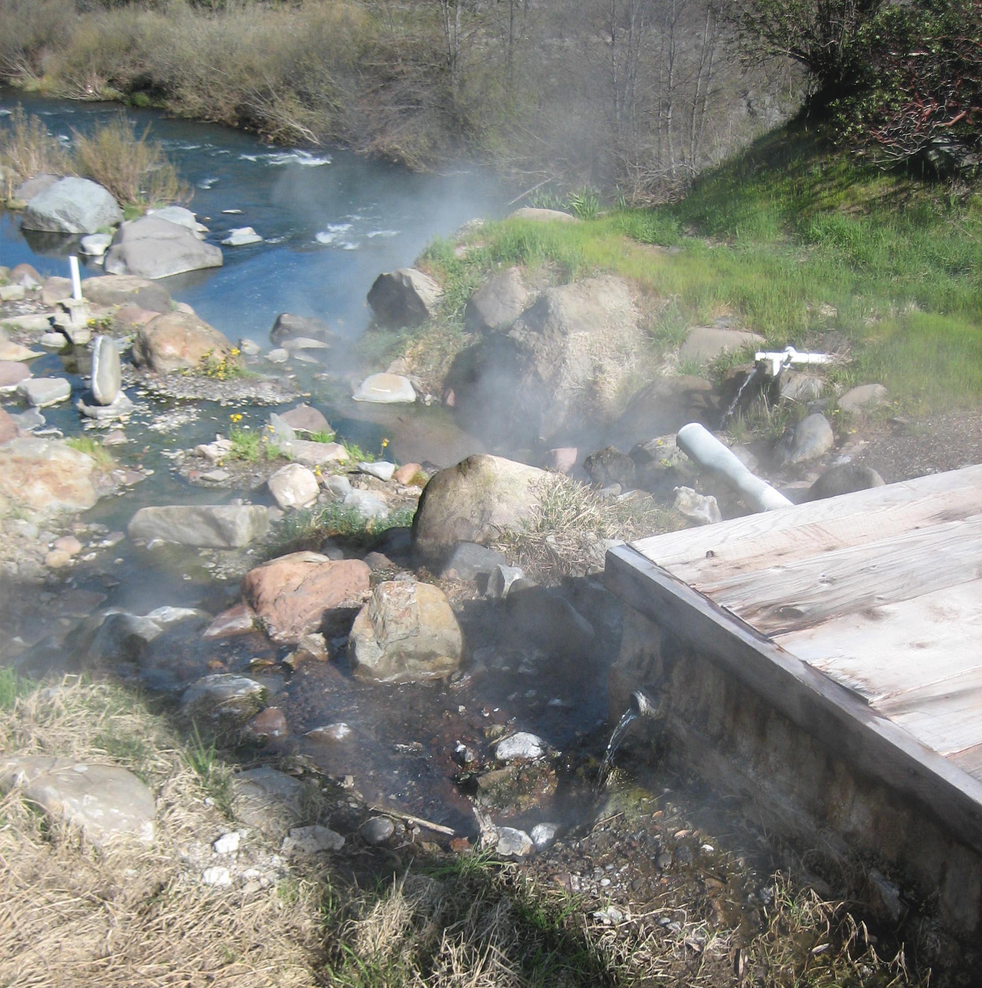
“The Mother Source”: This remarkable hot spring is the most productive and accessible hot springs at BBHS, and is a precious and sacred resource- a true gift from Mother Earth. One of our main priorities is to repair and improve the hot water collection system at the Mother Source”, which has an old and malfunctioning spring box, with numerous leaks and seeps and pipes that need to be cleaned up and simplified with a new central reservoir for the most efficient use. The Mother Source spring box can no longer contain the approximately 80 GPM outflow in the spring box, because decades of erosion has undermined the containment seals, so there is a lot of water leaking out from under the spring box.
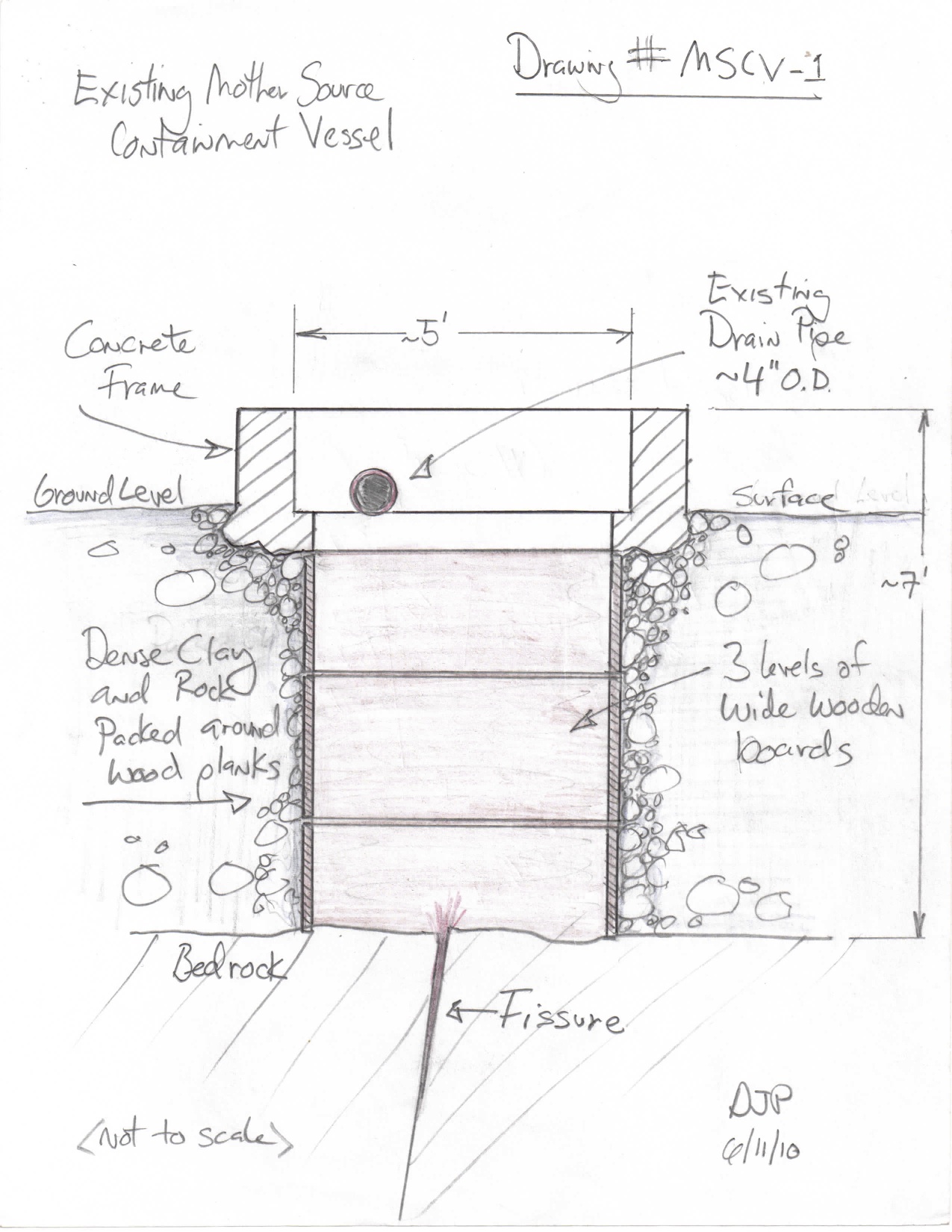
Improving The Mother Source Containment Vessel (“MSCV”):
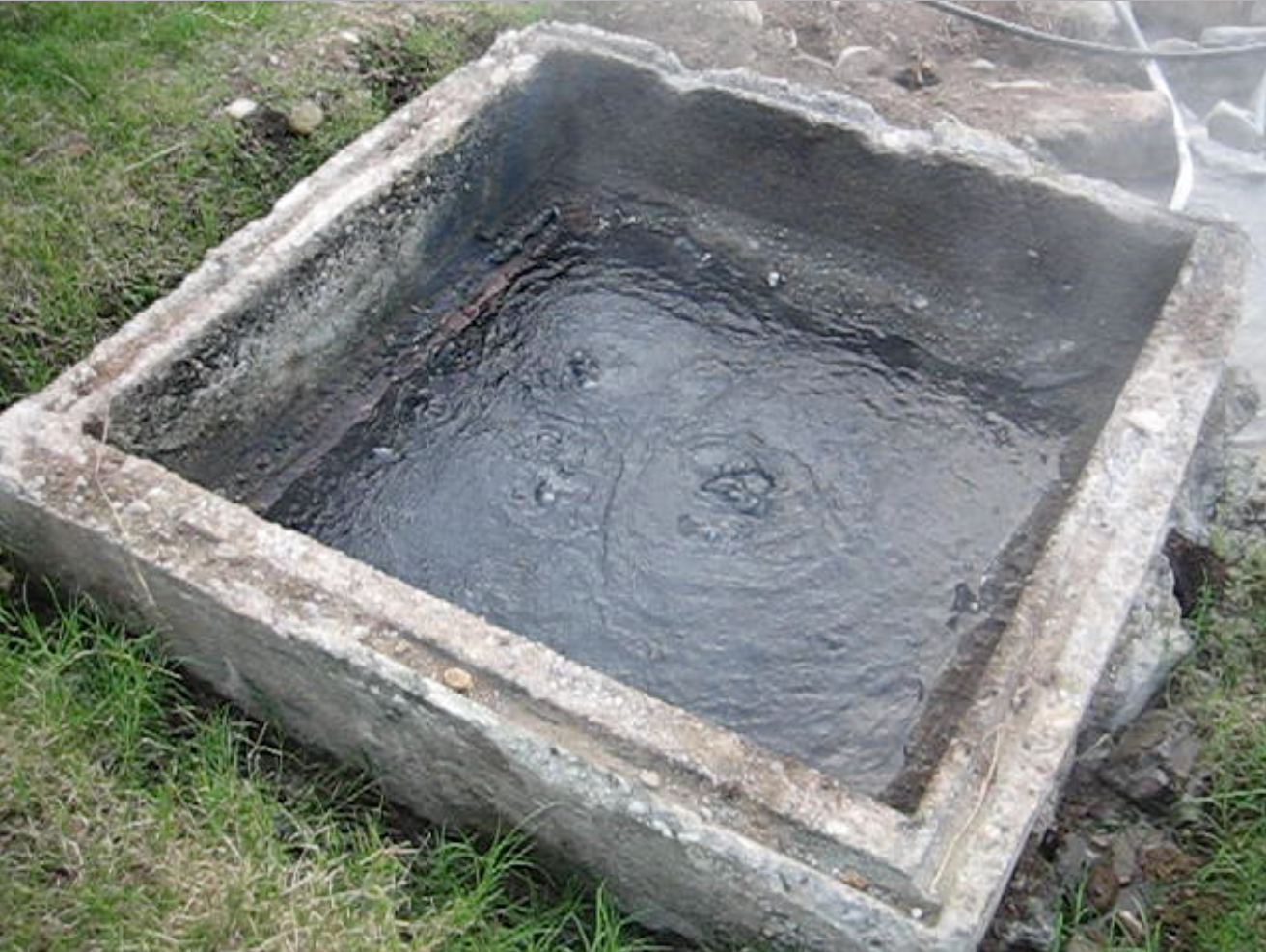
The Mother Source Containment Vessel (MSCV) is an old wooden and concrete spring box (probably built in the 1930s or 1940s?) that channels most of the water in its hot spring location into a useable vessel reservoir (about 5′ square), but it is in a state of serious deterioration and is increasingly leaking from decades of erosion underneath the box and in various cracks and seeps. Our goal is to repair it so the hot spring water will again be contained, for more efficient use and less river bank erosion:
There are also numerous seeps around and below the Mother Source, so we are looking into creating a small collection reservoir several feet below the Mother Source, in which most of the geothermal seeps of that hot spring zone could be collected for energy, heating, and soaking use with maximum efficiency. Big Bend Hot Springs Project is working on plans to find the best way to repair the MSCV for the sacred hot spring (Madesi name is apparently Lah-lah-Pis-Mah Hot Springs), which will allow some of the hot water to be pumped up to the geothermal electric generator.

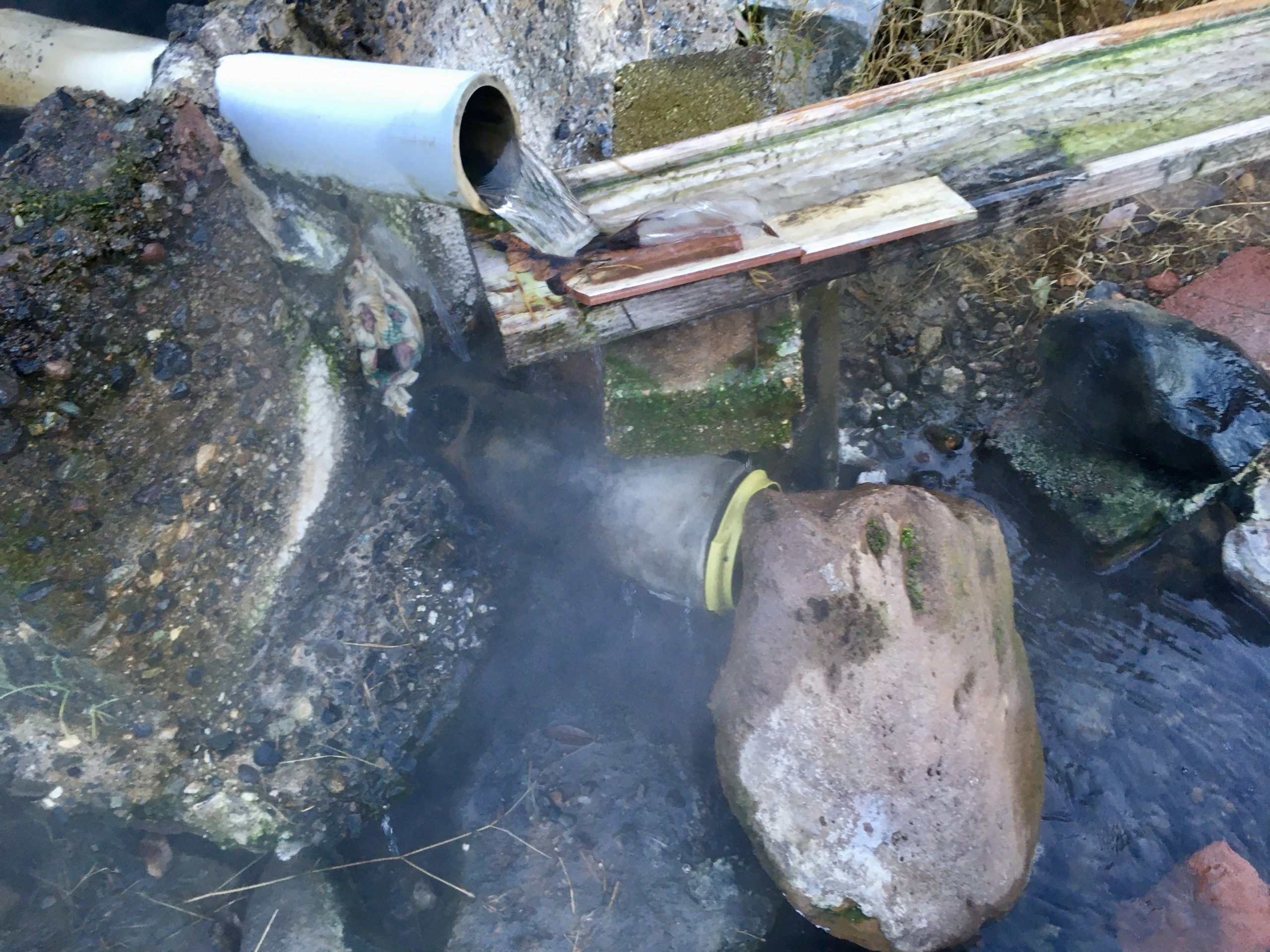
In the picture below, you can see the lower plug (yellow-green bowl with rock leaning on it), and the water coming out of the top pipe. What’s less visible is the many GPM that are leaking out, below the bottom (now plugged) pipe, and under the concrete wall, which frames the spring box top, and holds the outflow pipes in place. There is also some water leaking from cracks in the box rim (one has a rag shoved in it below the top pipe but it continues to leak, at a reduced rate).
MSCV Problems:
We used to get 80 GPM of 180ºF water from this vessel/pipe. Over the years, things have changed. The water has found some new paths of least resistance under and around the MSCV, so it’s difficult to capture or channel higher volumes until we somehow repair the MSCV. Besides the plentiful Mother Source water leaking out from under the concrete box, there are also some hot seeps near the MSCV that seem to have increased their flow over the years.
There is also a pipe that drains the flows under the slab of the old bathhouse (torn down and removed in 2009), that looks like it’s running at about 7 GPM (?). Here are the data collected in December of 2020, while working on re-activating the Claw Foot Tubs at dusk (Ambient Outdoor Temperature: 33ºF):
The Next Big Step: Repairing the MSCV will allow the use of some of its output to be used for the power generator and some of the hot water to restore the gravity flow piped down to the small terrace with the claw foot tub deck (slightly down river with only a slight elevation drop from the Mother Source), we needed to seal the leaks and rebuild the upper portion of the spring box, and thus raise the level of the water in the MSCV (Mother Source Containment Vessel), so the overflow will come out at a slightly higher elevation.
Some Recent Measurement Data:
•Mother Source Water Temperature in Box (no lid): 179ºF
•Mother Source Water at Top Pipe Outlet: 178.5ºF
Other Mother-Source-Related Hot Water Nearby:
1. Seepage puddle pool near Mother Source: 171ºF (4-5 GPM?)
2. Slab drain outlet pipe (under Reservoir Tub): 169ºF (5-7 GPM?)
Mother Source to Claw Foot Tub Gravity-Fed System:
•Mother Source Water Temperature in Box (no lid): 179ºF
•Mother Source Water at Top Pipe Outlet: 178.5ºF
•Water exiting open-air aqua duct system: 162.6ºF
•Reservoir tub by intake pipe (top of pex line): 153ºF
•Bottom of Pex line (output at Claw Foot trough: 145ºF
•Water in distribution trough at Claw Foots: 143ºF
•Claw Foot slow fill setting: 130ºF
•Claw Foot fast-fill setting: 138ºF
Our current main challenge and first priority is to repair the MSCV, so it no longer leaks and the flow is fully contained. If the new MSCV spring box contains adequately and has higher walls on the top box, we hope the level of the water will be higher, which would allow gravity-fed hot water to more locations and at higher volumes. When the new MSCV is in place and working, we believe the flow rate will be approximately 80 GPM. We plan to pump 50 GPM of that scalding water to the nearby Geothermal Power Plant.
Eventually, we will consider creating an additional unobtrusive collection reservoir below the Mother Source to collect additional hot water from the associated seeps around the Mother Source. All the water that will be used from this hot spring area will circulate and the return to its natural artesian site and flow down the river bank and into the river, as it has likely been doing for many thousands of years. The water will be cooler when it enters the river, which is good for the health of the river and the many organisms who thrive more in colder water. We will keep you posted about new design ideas and progress!
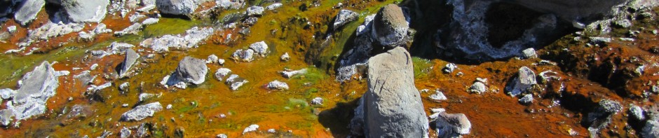
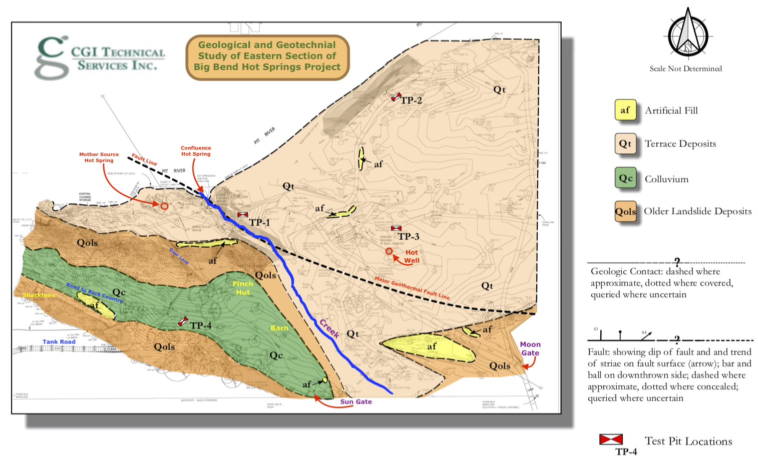
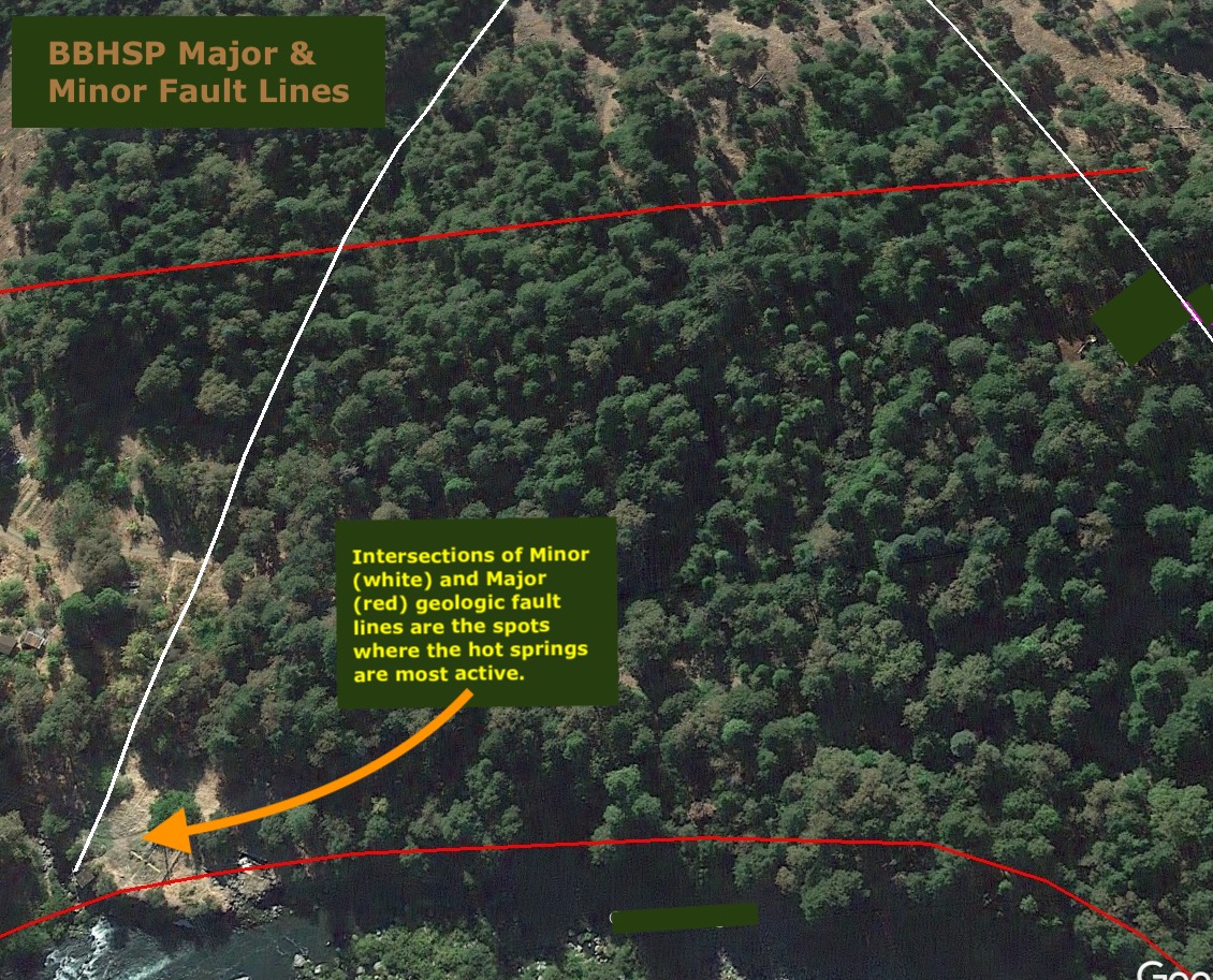
The hot springs are located along the region’s major geologic fault line (a crack in and below the bedrock that runs mostly along the ISS Creek and the Pit River), where minor fault lines also intersect with the major fault line, and this is where the hot springs are allowed to flow up to surface levels.
Among the various geothermal sources along the banks of the Pit River, the water temperatures and the GPM (Gallons Per Minute) flows are fairly consistent, but with some seasonal variations and apparent changes in the mysterious underground hydrogeology.
At least four exploratory geothermal wells (on both sides of the Pit River) were drilled without much success in 1988, but one of them is very productive and useful (Artesian Hot Well #1, at 1200 feet depth!). The other geothermal wells do not seem very productive (and would require pumping), so we are considering options to access more of the abundant hot water, to increase the amount of electricity we can generate from the excess scalding heat.

These elevations were obtained by using an adjustment factor of 690 feet higher than the professional surveyors, who used the corner property marker as a baseline guide (at 1,000 feet), and surveyed everything, using that as a base of reference. So it appears that that actual base point is not 1,000 feet above sea level, but actually 1,690′. We are in the process of double checking this elevation data with local topographical maps, Google Earth, and GPS technology.


(*Measured data shown may have changed & some data are estimates*)